Long before Rome had emperors, it built a road that refused to think locally. Follow the Appian Way south, past the names of the dead and toward the sea.
First came a military necessity
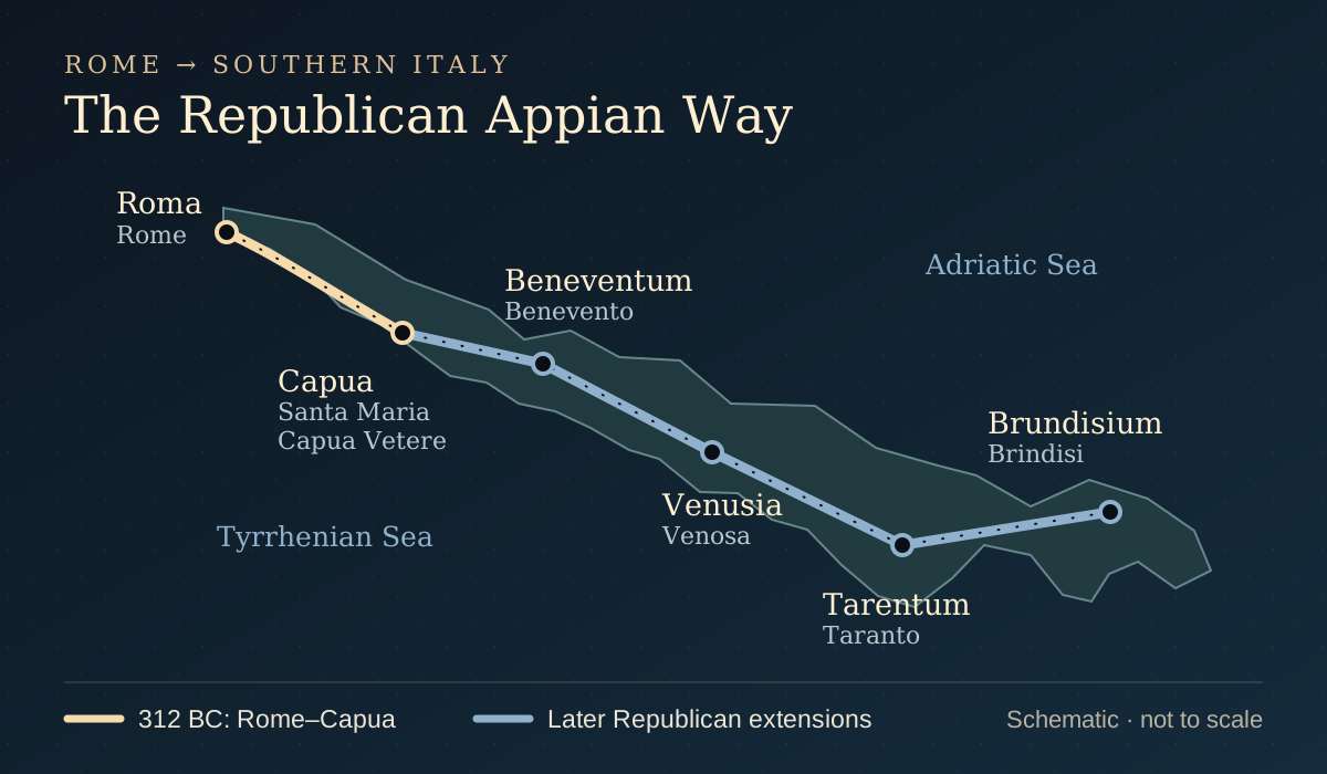
In 312 BC, the censor Appius Claudius Caecus commissioned a road from Rome to Capua. Rome was expanding into southern Italy; moving men and supplies mattered more than providing a picturesque Sunday walk. The original project became a much longer Republican route, reaching Beneventum, Venusia, Tarentum, and finally Brundisium—the modern port of Brindisi. The Italian Ministry of Culture describes this itinerary as roughly 540 kilometers long. [1]
That distance should change how we imagine a Roman road. It was not merely a handsome strip of stone outside the city. It connected inland communities with ports and sea routes. A soldier leaving Rome could be stepping into a system that carried him well beyond anything visible from his starting point.
Read the map in layers. Gold marks the first Rome–Capua connection. Blue continues the later Republican itinerary. These stretches were not all built in 312 BC. In AD 109, Trajan inaugurated a separate, easier route from Beneventum to Brundisium: the Via Traiana. It belongs to a later Roman world, not the soldiers’ 44 BC. [2]
The infrastructure of an ordinary journey
Conquest was only part of the road’s life. Settlements, trade, and agriculture developed around it. Milestones measured distance; fountains served travelers and animals; stopping places provided accommodation. The surviving heritage encompasses bridges, canals, and other engineering works as well as paving. Rome’s reach depended on the unglamorous business of keeping people moving. [2]
A road means thirst, fatigue, a place to stop, and the prospect of putting one foot in front of the other again tomorrow. The route stretches beyond the map into the traveler’s body. Marcus’s world has distances that cannot be wished away. An excellent road does not make the traveler’s feet immortal.
The dead beside the living
Why do tombs line the roads out of Rome? The surviving text of the Twelve Tables prohibits burial and cremation inside the city. That rule helps explain the funerary landscape beyond it, where successive generations left monuments beside a road that remained in use. [3]
A tomb beside a busy road could keep a name in the company of the living. Travel and remembrance occupied the same landscape. For the novel’s men, the road is therefore not an empty countryside that happens to contain graves. It is a place where Rome continues to speak about its families, status, and obligations.
A familiar landmark that is too young
The cylindrical tomb of Caecilia Metella is one of the Appian Way’s defining sights today. The archaeological park dates it to 30–10 BC: later than the novel’s 44 BC. Its travertine exterior, concrete core, and subsequent medieval incorporation into the Caetani fortress belong to different chapters of the site’s history. [4]
That is the pleasure—and the trap—of walking around Rome. A single view offers centuries at once. The road the soldiers know is not every monument that a visitor can photograph beside it now. Familiar ground does not guarantee a familiar world.
Planning a visit? Start with the regional park’s official route guides and the archaeological park’s monument information. Our diagram explains the historical route; it is not a walking or driving map.
KEEP EXPLORING
Sources & further reading
- Italian Ministry of Culture: Via Appia, Regina Viarum
The 312 BC foundation, original Capua connection, subsequent stages, and approximate length of the Republican itinerary.
- UNESCO World Heritage Centre: Via Appia, Regina Viarum
Historical development, travel infrastructure, and the distinction between the Appian Way and Trajan’s AD 109 route.
- Harvard Ames Foundation: The Twelve Tables, Table X
English translations of the surviving funerary-law fragments. The prohibition is a general legal rule, not an exhaustive account of Roman burial practice.
- Appia Antica Archaeological Park: Caecilia Metella and the Caetani complex
The monument’s 30–10 BC dating, construction, and later medieval reuse.